


Chet Van Duzer: Jeannette D. Black Memorial Fellow, 2010-2011 The Yale Martellus Map of ca. 1491 |
 |
|||
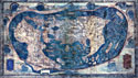
During my fellowship at the JCB from March to June of 2011, I studied a large world map made by Henricus Martellus, a German cartographer who worked in Florence. The map was made in about 1491 and it is now on permanent display in the Beinecke Rare Book and Manuscript Library at Yale. This map is of tremendous importance to Americanists: it is the best contemporary cartographic representation of the geographical concepts of Christopher Columbus, and indeed there are very good reasons to think that Columbus saw the map or another similar one by Martellus. The Yale Martellus map has been hailed as “a ‘missing link’ which has long been postulated and sought for by historians dealing with the ideological background to the discovery of America.” In addition, in terms of its projection, layout, and some geographical details, the map is quite similar to Martin Waldseemüller’s world map of 1507, one of the most important of the early sixteenth century. |
|
|||
Yet very little work has been done on the Yale Martellus map, particularly not since the burst of interest in the first few years following its discovery in 1959 and its anonymous donation to Yale. An important reason why so little scholarly attention has been devoted to the map, which is hand-painted, is that most of the texts on it are all but illegible. While a few of the toponyms in banners and texts in cartouches are readily legible, in the vast majority, the paint used to write the toponyms and legends has faded to a color very close to that of the land or other background, and in addition the surface of the map has suffered extensive rubbing or chaffing. This combination has rendered the texts extremely difficult or impossible to read. |
||||
I undertook a study of the legends on the map using new, high-resolution natural light, infrared, and ultraviolet images of the map, with the goal of determining just how close its relationship with Waldseemüller’s 1507 map is. I felt that if I could show that Waldseemüller had borrowed texts from Martellus, I could not only connect one of the most important late fifteenth-century maps with another of the early sixteenth century, but also gain insights into his choices as a cartographer and methods of working, insights that would be particularly valuable given the dearth of other information about Waldseemüller’s workshop and methods. |
||||
The results confirm that the Martellus map, or one very similar to it, was a crucial source for Waldseemüller in the creation of his 1507 map, particularly with regard to the long legends. At the same time, I was able to show that Waldseemüller did not slavishly follow Martellus: while he borrowed many texts from Martellus, he altered, adapted, and ignored various other elements in Martellus’s map in the process of creating his own image of the earth—and of course he added the New World. Waldseemüller followed a similar procedure in creating his Carta marina of 1516: he used Caverio’s manuscript nautical chart of c. 1504 as a model, but added many details, placenames, images, and legends to that foundation from his extensive study of recent travel literature. |
 |
|||